Sharing Your Results
Learning objective
By the end of this page you'll be able to get GeoE3's raw grid results out of QGIS (as a vector or raster layer, or exported to CSV), and know where every file an analysis produced actually lives on disk.
One last thing worth showing is how to access the raw data that's produced. GeoE3 adds layer groups to your project with a nested structure similar to the model tree. You can see all the outputs for each dimension, and each one shows the details relating to it. Right-click over any node and you'll see a whole bunch of menu items starting with Add (the same right-click menu introduced on The Interface):
- Add GeoE3 Score to Map: either a vector grid or a raster grid. If you want to work with the vector grid, you can go and look in its attribute table and see all of the indices that were calculated across the whole study area. Export this to a CSV, take it to your AI application or a spreadsheet, and do further numerical interpretation using that software.
- Add GeoE3 Aggregates to Map: the subnational breakdown, like you saw in the PDF report. If you use the Identify tool you can click on any one of these and see the area name and the majority score, basically the highest score for the region.
- There are more products in the menu too: outputs masked by job opportunities, the global human settlements layer used for the settlements masking, and so on.
- Open Working Directory takes you to the place where all of the analytical outputs were produced, including the reports and all of the data sets that were made during the analysis.
The study area grid
The foundation underneath every one of these outputs is the
study_area/ GeoPackage created back when you created the
project: the
regular grid (hexagons for a regional analysis, square cells for
national or local) that every indicator, factor, dimension and the final
GeoE3 Score is calculated against. You can hand that GeoPackage to a
colleague who wants to build their own analysis on the same spatial
framework.
Building a country pack
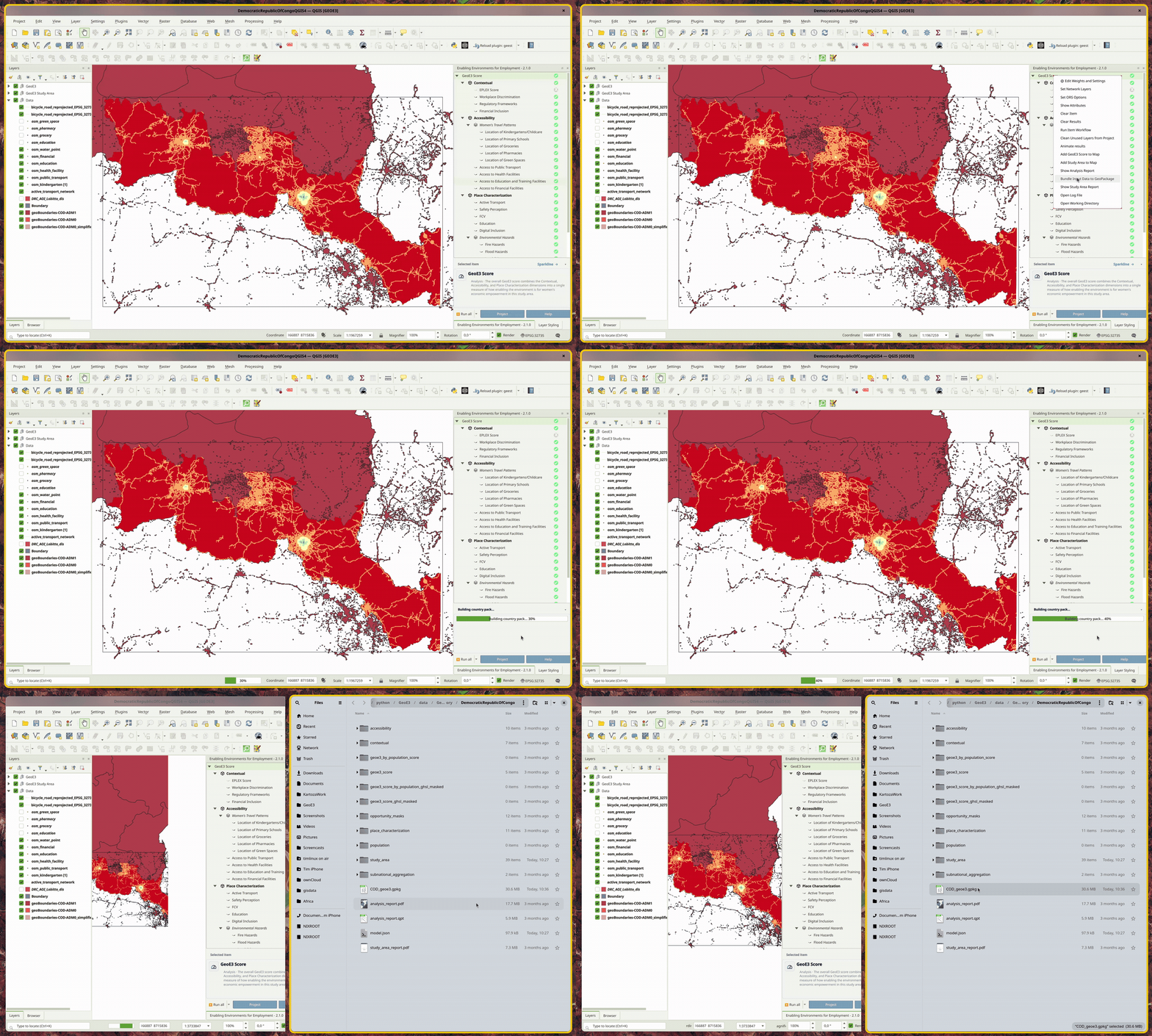
Data bundles allow you to easily share the same spatial framework with a colleague. Use the right-click menu on the GeoE3 Score node and use the Bundle Input Data to GeoPackage menu item to package the study area, all configured inputs, all computed results, and the model itself into a GeoPackage. You can then give that single file to anyone, and Import a Country Pack (see The Interface) rebuilds the whole project from it, ready to run without any further setup.
Recap
- The raw grid is yours to use beyond QGIS. Add it as a vector layer and export its attribute table to CSV for further analysis elsewhere.
- Add GeoE3 Aggregates to Map gets you the subnational breakdown; the Identify tool reads off each region's name and majority score.
- Bundle Input Data to GeoPackage packs the whole project (inputs, results, and the model) into one file. Import a Country Pack rebuilds it from that file, ready to run.
- Open Working Directory gets you straight to every file this
analysis produced, including the
study_area/GeoPackage every output is built on.
That should get you up and running with the basics of using the GeoE3 plugin, from an empty QGIS install through to a finished, reportable analysis. There are more things you can do beyond this walkthrough: the Legacy Detailed Reference covers a few individual factors in more granular detail, and About has the background on the framework this tool implements.
If you'd like to get in touch (feedback, questions, or to help), the Acknowledgements page has contact details for the team.