Data Collection#
This page provides guidance on finding and collecting relevant data for the GEEST tool, using Saint Lucia as an example. The data sources, layers, indicators and the table structure shown here can serve as references when gathering data for other countries.
Data Sources for Saint Lucia#
| DIMENSION | FACTOR | LAYER | DATA SOURCE/QUERY |
|---|---|---|---|
| 📝CONTEXTUAL | 🏢Workplace Discrimination | WBL 2024 Workplace Index Score | WBL 2024 index score |
| ⚖️Regulatory Frameworks | WBL 2024 Pay+Parenthood Index Score | WBL 2024 index score for Pay and Parenthood | |
| 💵Financial Inclusion | WBL 2024 Entrepreneurship Index Score | WBL 2024 index score for Entrepreneurship | |
| 🚶ACCESSIBILITY | 🚶♀️Women's Travel Patterns | 👶Location of kindergartens/childcare | Humdata or OSM |
| 🏫Location of primary schools | Humdata or OSM | ||
| 🛒Location of groceries | OSM | ||
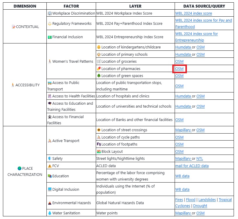
| 💊Location of pharmacies | OSM | ||
| 🌳Location of green spaces | OSM | ||
| 🚌Access to Public Transport | Location of public transportation stops, including maritime | OSM | |
| 🏥Access to Health Facilities | Location of hospitals and clinics | Humdata or OSM | |
| 🎓Access to Education and Training Facilities | Location of universities and technical schools | Humdata or OSM | |
| 🏦Access to Financial Facilities | Location of Banks and other financial facilities | OSM | |
| 🌍PLACE CHARACTERIZATION | 🚴Active Transport | 🚸Location of street crossings | Mapillary or OSM |
| 🚴♀️Location of cycle paths | OSM | ||
| 👣Location of footpaths | OSM | ||
| 🏘️Block Layout | OSM | ||
| 🛡️Safety | Street lights/Nighttime lights | Mapillary or NTL | |
| ⚠️FCV | ACLED data | mail for ACLED data | |
| 📚Education | Share of graduates by field, female (%) | WB data | |
| 💻Digital Inclusion | Individuals using the Internet (% of population) | WB data | |
| 🌋Environmental Hazards | Global Natural Hazards Data |
General Data Source: Fires | Flood | Landslides | Tropical Cyclones | Drought Direct Download Link: 🔥 Fires Download | 🌊 Flood Download | ⛰️ Landslides Download | 🌀 Tropical Cyclones Download | 🌵 Drought Download |
|
| 💧Water Sanitation | Water points | Mapillary or OSM |
Potential Data Sources for Other Countries#
While the above table showcases data specific to Saint Lucia, similar data can be found for other countries through the following sources:
World Bank - Women, Business and the Law: Offers indices on workplace discrimination, regulatory frameworks, financial inclusion, and more, helping to track progress on women’s economic empowerment across countries.
United Nations Development Programme (UNDP): Provides metrics on gender equality, economic participation, and sustainable development, essential for evaluating contextual and place-based factors.
National Statistics Offices: Many countries publish gender-disaggregated data, which is crucial for contextual and accessibility insights in specific regions.
International Labour Organization (ILO): Collects data on labor force participation, wage disparities, and workplace regulations by country, supporting the analysis of gender gaps and regulatory environments.
OpenStreetMap (OSM): A valuable open-source platform providing geospatial data, including the locations of educational, healthcare, and financial facilities, as well as transport and green spaces. OSM data can help assess accessibility and environmental factors at a local level.
Humanitarian Data Exchange (Humdata): Maintained by the United Nations Office for the Coordination of Humanitarian Affairs (OCHA), Humdata offers open datasets on schools, health facilities, and other infrastructure, aiding in the geospatial analysis of services critical for accessibility assessments.
Global Natural Hazards Data: Provides data on environmental hazards, including earthquakes, floods, cyclones, landslides, fires and others across regions. This data is essential for assessing natural risks and planning in vulnerable areas.
Mapillary: A collaborative platform that offers street-level imagery contributed by users worldwide. Mapillary data includes vector data on street crossings, sidewalks, and public lighting, making it useful for place-based and accessibility assessments.
Instructions for Data Collection:#
Query the Source: Use the query instructions provided in the table to filter and collect specific data.
Check Availability for Each Country: Not all indicators may be available for every country; adapt based on what is accessible.
Document Sources and Methods: Record each source, method, and any specific details relevant to your data collection process.
Contextual factors#
To access the data for inputting into the tool, visit the provided World Bank WBL page and follow the next steps:
Select a region from the dropdown list:
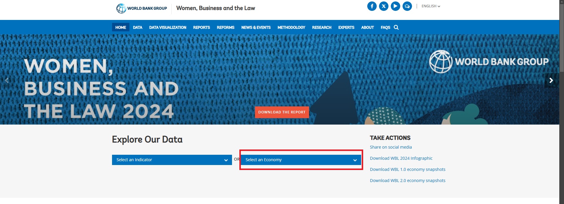
After selecting the country, the new webpage that opens provides the necessary information for input into the plugin. The data includes:
WBL Index Score for the Workplace Discrimination factor.
Pay and Parenthood scores for the Regulatory Frameworks factor.
Entrepreneurship score for the Financial Inclusion factor.
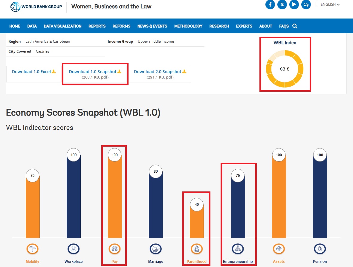
Accessibility and Place Characterization factors#
1. Using Humdata source
Visit the Humdata webpage and search for the required factor to retrieve the necessary data for the tool as in the following example:
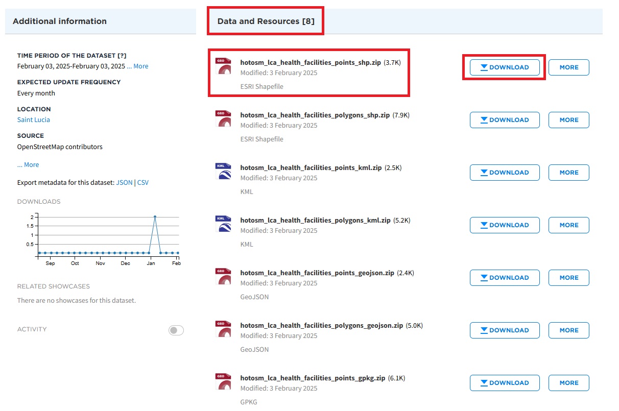
Search for “health facilities for Saint Lucia” in the search bar and click on the most relevant link to access the dataset:
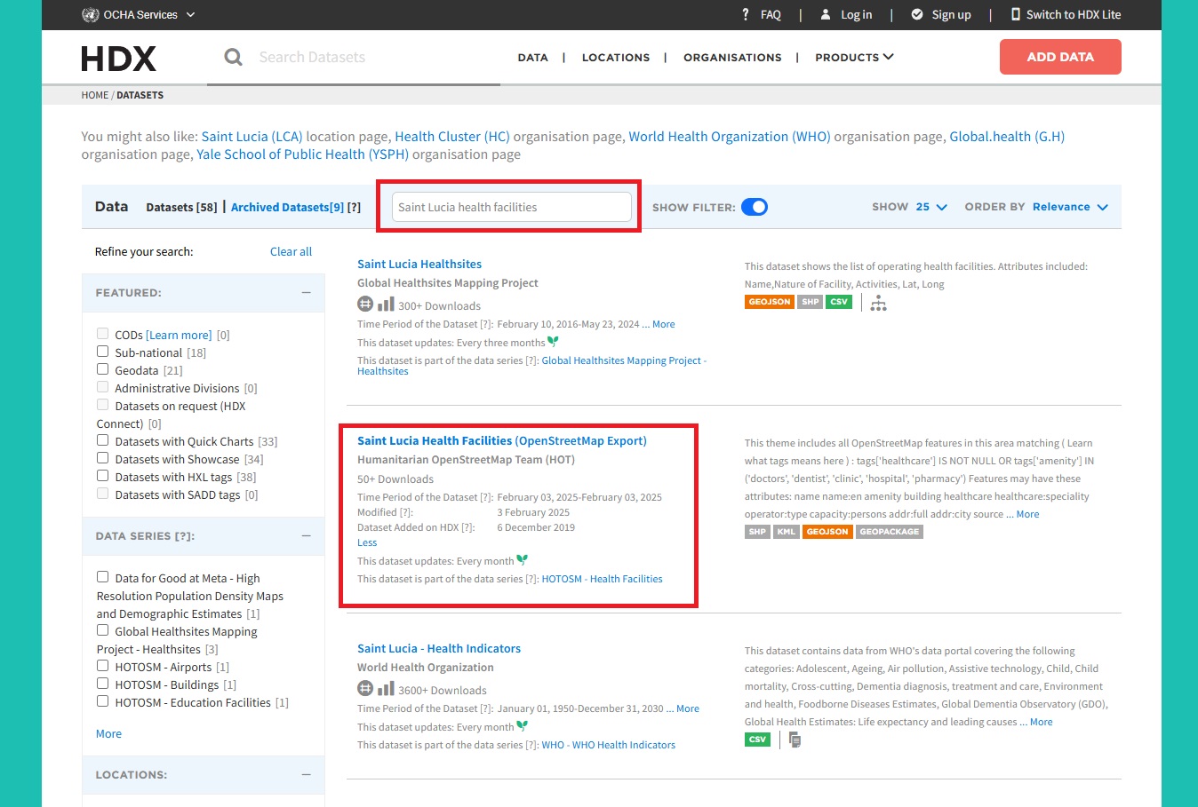
In the newly opened webpage, scroll down until you reach the Data and Resources section and locate the dataset corresponding to shapefile point data and click on the Download button next to it:
2. Using OSM source
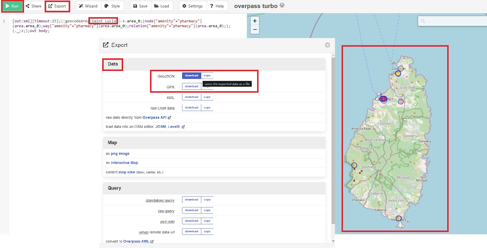
Click on the links in the table provided above as in the following example (pharmacies):
In the newly opened webpage, change the country selection to match your region.
Click on the Run button to load the available datasets, which will be displayed within the right map extent.
Click on the Export button.
In the new pop-up, under the Data section, click on the download button next to the GeoJSON format and save the dataset locally to your machine.
Open QGIS, add the downloaded data and export it as a shapefile format for further processing.
