Vietnam Boundary Comparison
Contents
Vietnam Boundary Comparison#
import sys, os, importlib, json, multiprocessing
import folium, shapely, rasterio
import pandas as pd
import geopandas as gpd
import numpy as np
from shapely.geometry import Polygon, Point, mapping
from shapely.ops import unary_union
from urllib.request import urlopen
sys.path.insert(0, "../../gostrocks/src/")
import GOSTRocks.ntlMisc as ntl
import GOSTRocks.rasterMisc as rMisc
sys.path.append("../src")
from GOSTboundaries import boundary_helper
%load_ext autoreload
%autoreload 2
The autoreload extension is already loaded. To reload it, use:
%reload_ext autoreload
geobounds_url = 'https://www.geoboundaries.org/api/current/gbOpen/{iso3}/ADM{lvl}/'
sel_iso3 = 'VNM'
h3_lvl = 6
official_wb_bounds = f"/home/wb411133/projects/BOUNDARIES/Data/WB_med_res/{sel_iso3}_medium_res.geojson"
high_res_bounds = '/home/wb411133/projects/BOUNDARIES/Data/HighRes/WB_GAD_ADM_Samples/shp/WB_GAD_ADM2.shp'
output_folder = "/home/wb411133/projects/BOUNDARIES/"
html_maps_folder = "/home/wb411133/Code/Boundary_Comparison/docs/_static"
# Open official World Bank boundaries
selWB = gpd.read_file(official_wb_bounds)
inH = gpd.read_file(high_res_bounds)
selWB = selWB.to_crs(4326)
selH = inH.loc[inH['ISO_A3'] == sel_iso3]
comparer = boundary_helper.country_boundary(sel_iso3, selWB, "OBJECTID", geoBounds=selH)
comparer.run_all(run_h3_summary=True, run_comparison=False, run_zonal=True)
/home/wb411133/.conda/envs/ee/lib/python3.9/site-packages/geopandas/geodataframe.py:1322: SettingWithCopyWarning:
A value is trying to be set on a copy of a slice from a DataFrame.
Try using .loc[row_indexer,col_indexer] = value instead
See the caveats in the documentation: https://pandas.pydata.org/pandas-docs/stable/user_guide/indexing.html#returning-a-view-versus-a-copy
super(GeoDataFrame, self).__setitem__(key, value)
Matching bounds2 to bounds 1: 0%| | 0/681 [00:00<?, ?it/s]/home/wb411133/.conda/envs/ee/lib/python3.9/site-packages/pandas/core/indexing.py:1720: SettingWithCopyWarning:
A value is trying to be set on a copy of a slice from a DataFrame.
Try using .loc[row_indexer,col_indexer] = value instead
See the caveats in the documentation: https://pandas.pydata.org/pandas-docs/stable/user_guide/indexing.html#returning-a-view-versus-a-copy
self._setitem_single_column(loc, value, pi)
Matching bounds2 to bounds 1: 100%|██████████| 681/681 [00:22<00:00, 30.24it/s]
Matching h3 to bounds 1: 100%|██████████| 8144/8144 [03:06<00:00, 43.65it/s]
Matching h3 to bounds 2: 100%|██████████| 8144/8144 [03:16<00:00, 41.53it/s]
Comparing Boundaries#
There are substantive differences between the medium-resolution boundaries and the high-resolution boundaries; these areas are most prevalent in coastal islands and small, urban administrative units.
# Hanoi
comparer.map_boundary_comparison(Point(105.81492,21.02619), 12)
# Tra Ban Islands
comparer.map_boundary_comparison(Point(107.19508,20.88403), 11, buffer_dist=0.2)
This leads to variation in certain zonal statistics in these areas. In this experiment we ran the following comparisons:
ESA Globcover - determine the majority landcover class in each district
Nighttime Lights - calculate sum of lights for most recent month (2023-02)
H3 grid comparison - joined h3 grid cells to admin divisions and identified which h3 grid cells join the different administrative divisions based on resolution.
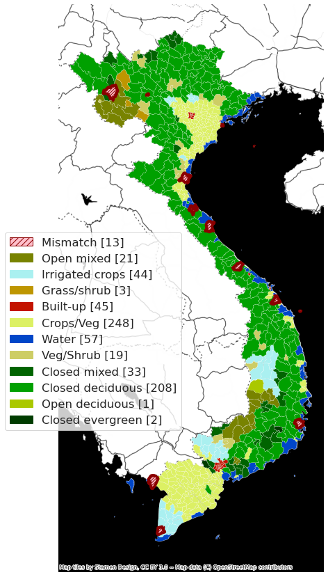
ESA Globcover#
This ~300m2 resolution landcover dataset classifies landcover into 23 categories.
For each admin division we calculated the majority class and compared between the medium and high resolution datasets
Of the 681 admin 2 divisions in Vietnam, 12 have a different majority landcover class.
cur_plot = comparer.static_map_lc(legend_loc=[-0.2,0.25])
cur_plot
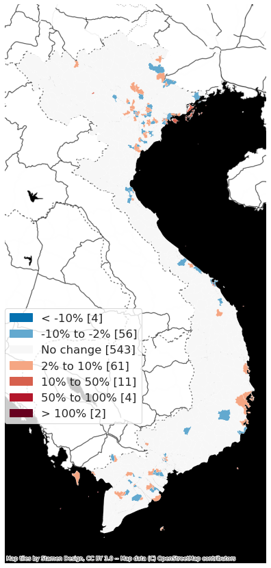
Nighttime Lights#
We calculated sum of lights for each dataset, and then compared them, as % change from medium-resolution boundary to high-resolution.
ntl_summary = comparer.ntl_summary(legend_loc=[0,0.25])
ntl_summary[0]
ntl_summary[1]
Number of districts with NTL change (medium to high)
< -10% 4
-10% to -2% 56
No change 543
2% to 10% 61
10% to 50% 11
50% to 100% 4
> 100% 2
Name: OBJECTID, dtype: int64
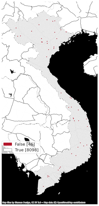
H3 grid comparison#
Using h3 grid level 6 (~36km2), there are 8144 individual h3 grid cells in Vietnam. Of those, 46 are identified as having different parental admin boundaries based on resolutions
mapp = comparer.static_map_h3(legend_loc=[0,0.25])